Susquehanna River: Preparations and Day 1 (Hoover Island to Millersburg)
*Originally published September 2022.

“Ed looked back briefly, flailing his paddle, struggling against the current. With a terrified look in his eyes, he disappeared into the rapids and was gone around the rocks. And now I was marooned. On an island. No shoes, no food, no water, no phone. Only a drone, a camera, and a replica of the Statue of Liberty in the middle of the Susquehanna River. Of all the contingencies we planned for, this was not one of them”
Preparations
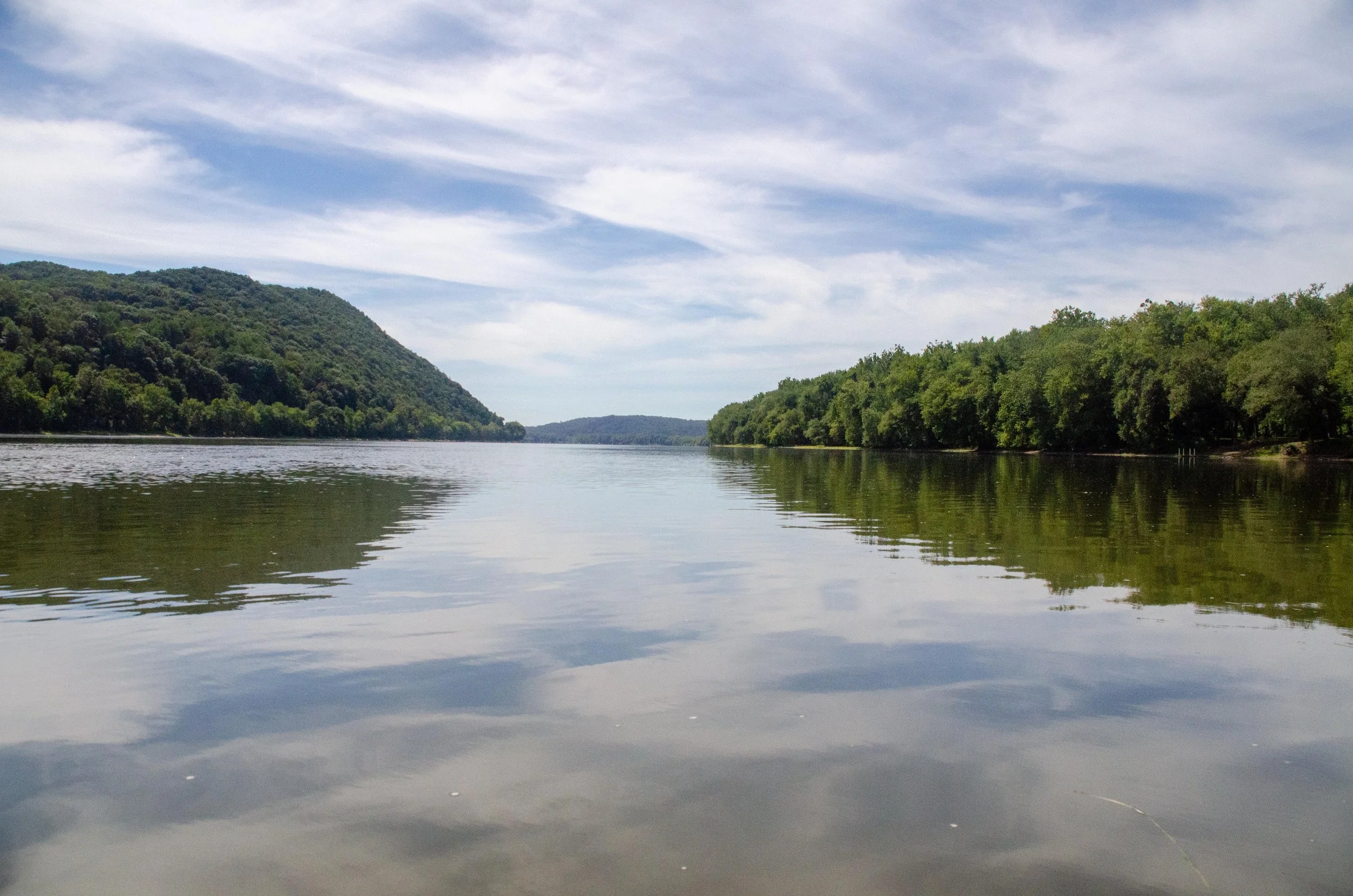
Returning to Pennsylvania, I have found comfort again in trees and, more notably, water. There is no question that the desert is a beautiful place with its rugged mountains, sunsets, and wild landscapes. But, as you may be aware, the desert is not well known for its water. Being back here, I’ve had to adjust to my surroundings again by acknowledging that I’m almost never more than a mile from a water source and that it rains nearly once a week here. Weird. My work often takes me into the central part of Pennsylvania across the Susquehanna River at Harrisburg and north along Route 11/15 towards Lewisburg. On many drives, I can see the wide river, dotted and broken up with lush, forested islands. The first time I saw those scattered islands, there was something about them that called to my inquisitive side. I wanted to get in a canoe, ride down the river, and explore these islands.
While brewing beer in February, Greg and I had this discussion with a friend of mine who had traveled parts of the Susquehanna. He noted that several of the islands have campsites and this heightened our desire to get on the water. My plan was to buy a canoe and start checking out nearby waterways, but I couldn’t find one that was within my budget. I looked at some local outfitters for a rental, but found none that suited our needs. So we turned to my friend to see if we could borrow his two kayaks. He obliged and that cemented it: Labor Day Weekend Susquehanna Adventure.
The prep work is incredibly critical and we attribute our success in many places from Yellowstone to Kenya to our dedication to researching everything we can and planning for a wide array of contingencies. Ed worked up an itinerary with a new fervor and was surprised to find few, if any, detailed maps of the best river courses. He mostly used Google Earth and Google Maps, Susquehanna Greenway Trail Association (https://susquehannagreenway.org/), and a handful of other sites. Greg pointed him to Main Flow Susquehanna River and Swatara Creek by J. Susco (https://www.kayakmapspa.com/). Armed with all of this information, we felt confident in our ability to get down the river without much drama.
The plan was to put in to the river at Hoover Island just south of Selinsgrove and travel the river to Island 97 near Millersburg (18 miles) or Island 93 near Halifax (23 miles) on the first day. The second day would take us down past Haldeman Island to Duncannon, where we planned to resupply on beer at Perry County Beer Store on the banks of the Little Juniata, and on to Island 82 near Cove. The third day would take us through the Dauphin Narrows past a replica Statue of Liberty in the middle of the river and down into Harrisburg to City Island. By all accounts, the average speed is 3 mph on the water. At that speed, we would be at campsites early in the afternoon, and we’d have lots of time for island-hopping. Total distance was planned at 45 miles.
Now it was time to figure out what gear we needed for three days.
As photographers, our first thoughts turned to what camera gear we were willing and able to carry down the river. We settled on a Nikon d750 with a Sigma 18-300 mm lens, a Nikon d750 with a Nikkor 200-500 mm lens and 1.4x Sigma teleconverter, and a Nikon d7000 with a Sigma 18-200 mm lens. The big lens would be carried in a Pelican case for ultimate protection from water and rapids. We purchased a small Akaso adventure cam for the trip and Greg packed his DJI Mavic Mini drone. Additionally, there was one tripod and both of our Lenscoat Lens Hides. These two latter items are small and we envisioned that on our leisurely saunter down the river that we would take the time to post up on an area in the early morning to photograph herons, egrets, or eagles and be camouflaged.
With photo gear out of the way, we turned to moderately more important things like what to sleep in/on and what to eat. With the last warm summer nights upon us, we decided to travel light and bring hammocks and rain flys. However, as we were unsure of the territory and the availability of campsites, we also packed a small two-person North Face tent and ground pads as insurance. We rounded out our camp gear with the usual accoutrements: sleeping bags, camp pillows, a small hatchet, jet boil stove, a small solar silicone lantern, paracord, knives, a kettle for boiling water, headlamps, lighters, Leatherman multi-tools, camp cups, an MSR water filter, matches, trash bags, camp stools, a deck of cards, and utensils. Greg insisted on a small frying pan for when he caught a fish.

There were electronic accessories: Greg’s GoalZero solar array for charging phones and to act as a potential landing platform for the drone while on the water, solar phone charger, battery bank, charging cables, a waterproof bluetooth speaker.
There were some contingency items as well: bear spray, bug spray (lots of it), duct tape, ropes of a wide variety of sizes and lengths, first aid gear, toilet paper and a shovel for the most unfortunate of potential events, an automotive sponge to help sop up stray water, and carabiners for attaching gear to boats.
Then there were clothes: bathing suits, zip-off pants, long sleeve shirts, rain jackets, towels, hats, water shoes and sandals, wool socks, and vests.

Important Gear
To protect our gear, we had a dozen dry bags of various sizes. Only one was left, and we decided to pack it with us as a spare.
There were navigation tools: maps, binoculars, a compass, our field books for notes, pencils.
We had fishing gear: a small tackle box, a small fishing pole, some bait, and a small 3lb anchor. The anchor was totally an impulse buy. I imagined we would want to stop dead in the river to photograph eagles or other birds without being pulled downstream.
There was kayak gear: paddles, life vests, an inflatable cooler itself to trail behind us, an air pump.
And finally, there was food: 8 peanut butter and jelly sandwiches, a bag of bagels, taylor ham, cheese (sliced and a block), four Mountain House dinner meals, gummy snacks, granola bars, trail mix, beef jerky, apples, a water bottle, a 2-liter water bladder, a 1 gallon water jug, a cooler full of ice, 12 Pabst Blue Ribbons, and a bottle of Kraken rum.
All that. In two kayaks and an inflatable cooler.
We fully recognize and admit that it was too much gear. However, the duration of the trip, the high number of unknowns, our belief that we would spend a significant amount of time photographing wildlife, and a desire to not fall ill or be injured, made us feel that although we probably overpacked, we were at least prepared for nearly any situation.
We spent the last week before the trip with daily updates and reviews of the gear. A list of pirate shanties was compiled because you can’t fly a pirate flag and drink rum on the water without singing some pirate shanties. Ed spent several days learning to tie various knots. We closely watched the weather, which was expected to be good. We sorted and organized gear and test-packed the kayaks the night before to help expedite our departure in the morning and get us on the river faster.
In our story below, italicized text is taken directly from our field notes.
Day 1: Hoover Island to Millersburg
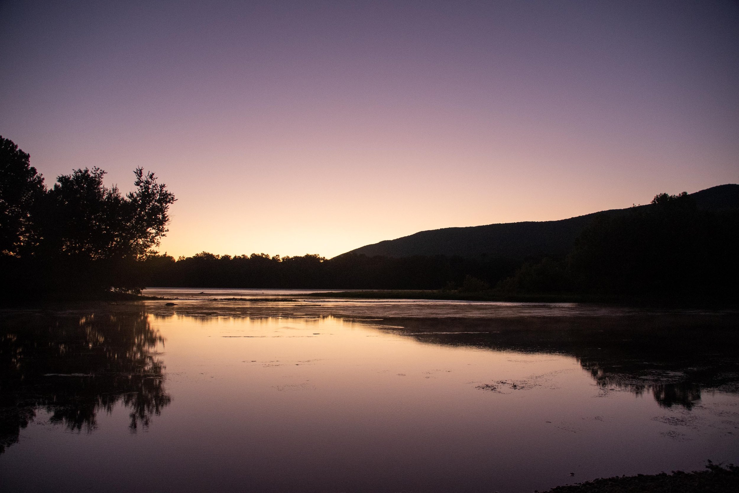
Dawn on the river.
Up at 330. Depart at 4. Did not sleep well. Too excited. “Roll the old chariot along” in head.
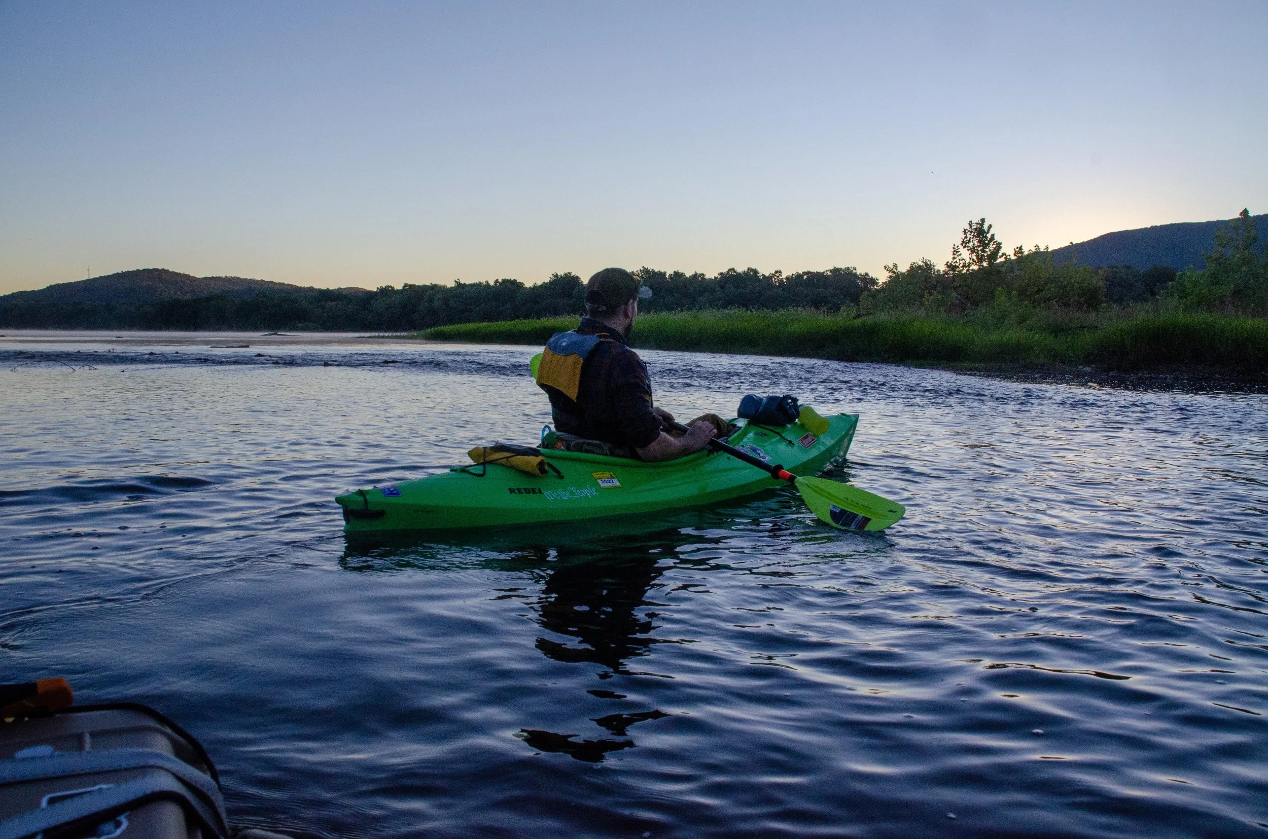
The drive up to the launch is about two hours from Ed’s house. We arrived just before 06:00, the sun starting to cast its light into the sky. Before we even got the boats off the truck, we saw a kingfisher, an egret, and an owl. A good sign and a good start. We launched at 06:45. So much for being speedy in sorting the gear the night before. The Pelican case, with the big camera in it, was strapped to the front of Ed's kayak, a yellow Potomac Pathfinder, nicknamed Big Yellow. The Pathfinder only has storage space at the fore of the boat (we’re using nautical terms here) and a very small area behind the seat. Therefore, Ed got to tow the trailer with the food in it. We armored the bottom of the trailer with duct tape the night before to help stave off any potentially disastrous holes in the material.
Greg was using a green Coleman Rebel, which had ample storage fore and aft, so he carried the bulk of the weight in our gear. The Pelican case made the boat too top-heavy and Ed rocked back and forth as he paddled out. He figured this was just getting accustomed to the feel of the boat and that it would pass.


A heron takes flight.
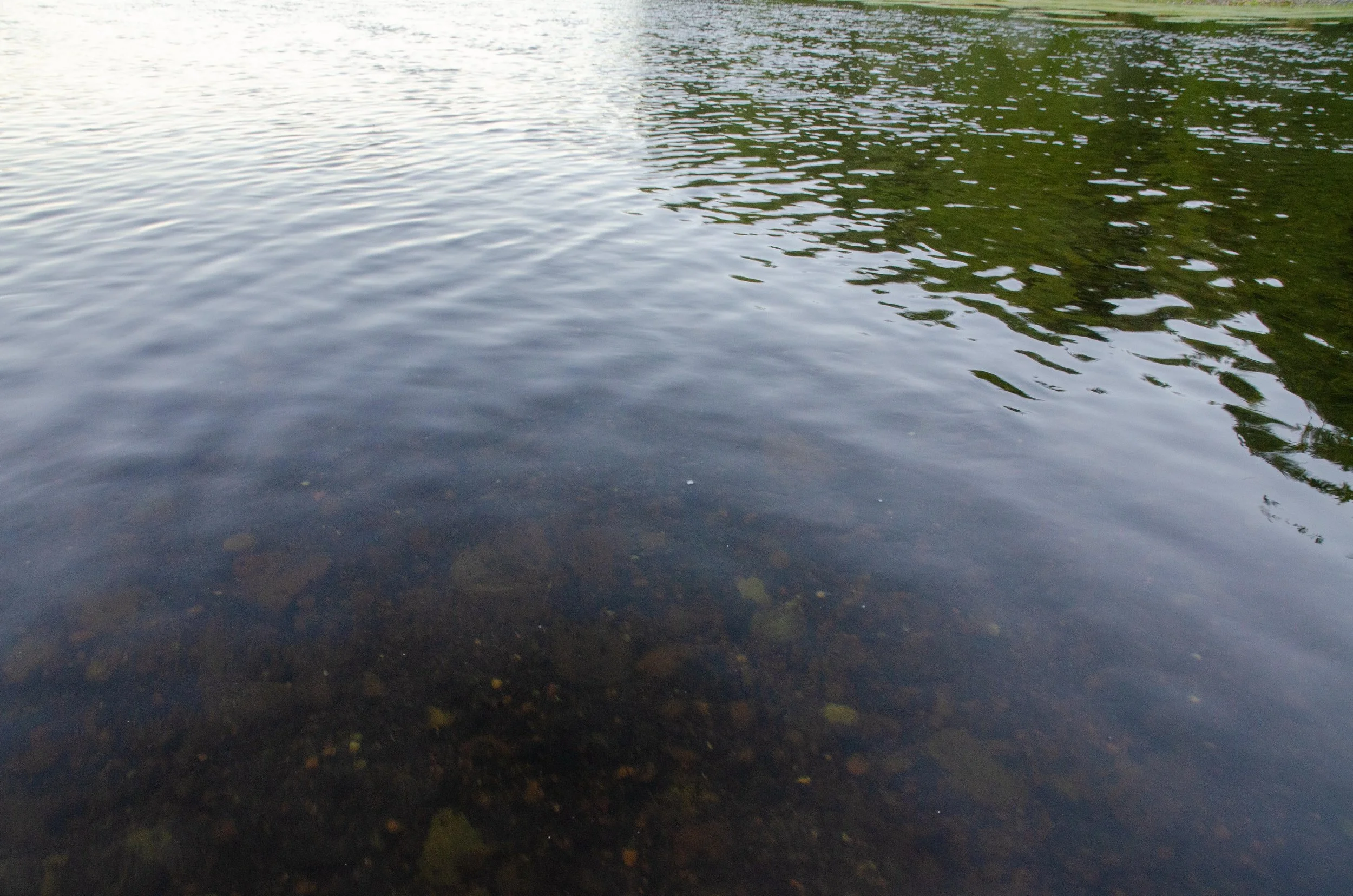
Crystal clear water.
The morning was cool, and a thin fog lifted as we got underway. The sun was still behind the mountains, but already we could see that the water was crystal clear and fairly shallow, only about a foot or so. Lush grasses carpeted the stony river floor below us. It wasn’t long before we reached the first challenge.
To understand the water on the Susquehanna requires an understanding of the geology of Central Pennsylvania. The rocks in this part of the state are between 450 and 250 Million years old and have been deformed as part of a mountain building event, which resulted in large, broad folds with generally the same orientation. Many geologists put the age of the Susquehanna River itself at approximately 300 million years old. More resistant layers of rocks form ridges and ledges, that can create small drops and rapids. These ledges are easy to spot as you travel downriver and if you understand that the formations have the same orientation throughout the water gaps, they’re easy to predict too.

Greg went first over the ledge. Ed followed, turned partly sideways, and took on an incredible amount of water, nearly capsizing. He managed to rotate back before being inundated, but it forced us to land.
Pull to shore at 07:00. Move Pelican case to trailer. Much better. Remove water from kayak. Take off. Stop again to adjust trailer length.

At 08:00 we stopped for a breakfast of candy cigarettes (yes! you can still find them!) and bagels. By our reckoning, we reached the end of White Island at 08:15 and attempted to get closer to the east shore but found ourselves in ankle-deep water. Too shallow for the boats, we walked them out until we found the deeper channel again. We saw a juvenile bald eagle as we headed river left around Carl’s Island.
Greg was off taking pictures of a Bittern and Ed took a moment to calibrate our maps to our position on his phone. We generally wanted to navigate old-school, but we’re glad that he used his phone. We were not at Carl’s Island. We were at the very southern tip of Hoover. A fairly sizeable difference. The summer drought had revealed new patches of land in the river that were not on our maps, tricking us into thinking we were in a different stretch of water. Ed relayed this news to Greg and we groaned (both from disappointment and the stiffening of our backs already).
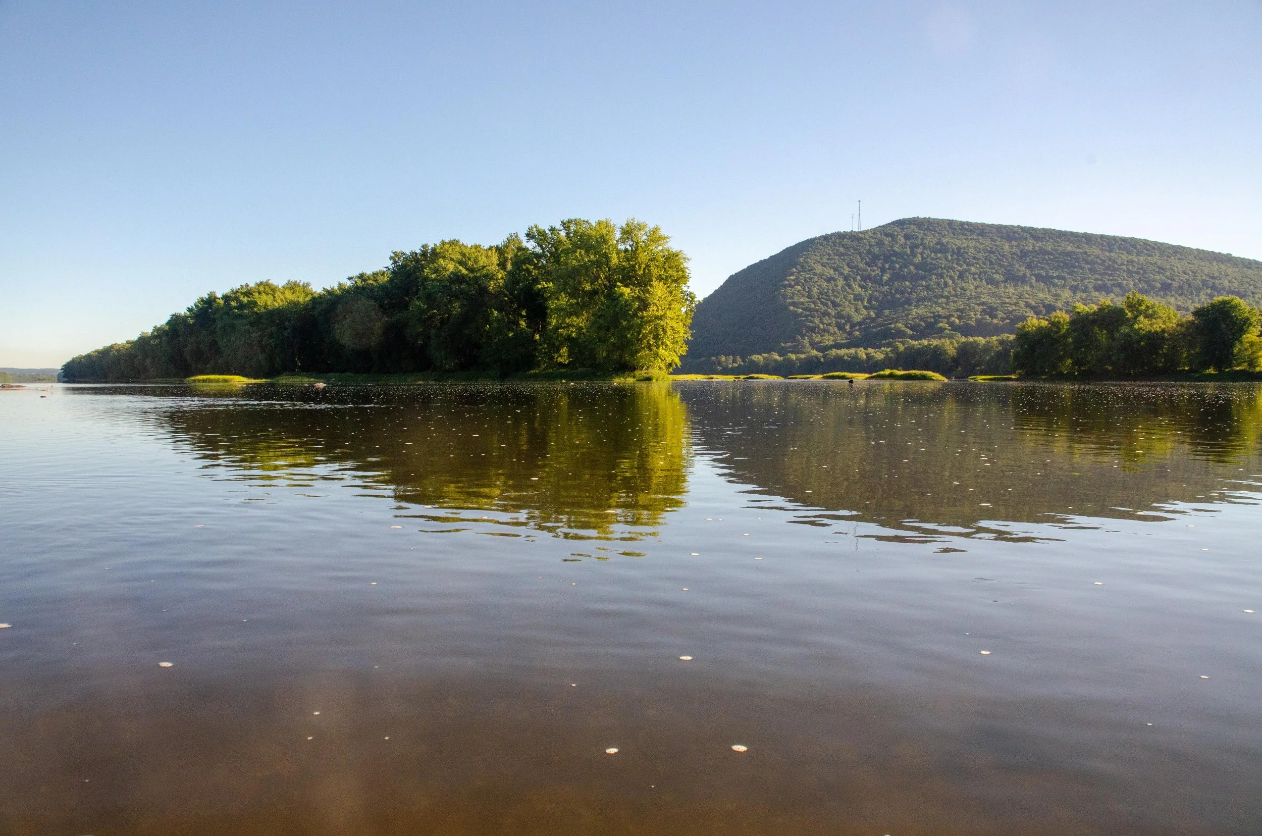


To make up some lost time, we paddled hard down the length of White Island. Towards the south end we came upon a series of islands that had once had bridge pillars on them and stopped for a rest. Greg took the opportunity to successfully catch a fish. The day was warming up nicely and we were back on the water at 10:00. Now we wandered through the south end of White Island, past Toad Island, Carl’s Island, and eventually reached the east bank by 10:40. These little islands were as we expected. They are wildly overgrown with reeds, bushes, brambles, and great big trees towering over the water. Birds of all manner flew across the channels. The waters were quiet, but still moved as we paddled on.


Make it through many rapids and shallows around Blood Island or Herrold Island. Stop for drone flight and prep for McKees falls.
More people were out now and we hastened to catch up to a large group in front of us as we approached McKees half-falls. McKees is is a series of closely-spaced ledges which form a set of rapids. Everything we read insisted that we ride river left and avoid the rapids on the right. The left was super lame and very shallow. We beached and benched regularly as we tried to get through, finally walking the kayaks to a deeper channel. The “rapids” themselves were nothing more than some marginally faster water dropping about a foot. We lost nearly half an hour there.
It was now 13:00 and we were well-behind schedule. A long stretch of placid water was ahead of us. A fair number of people were on this stretch of river and we pushed hard to catch up again. Towing the inflatable raft is like driving a semi or freight train. Once you get going, it’s best to stay going in a single direction. Slack in the rope behind Ed would tug when he would start up again, ever so slightly sapping his energy. So he found a good pace, let his mind wander, and pressed on. Greg fell far behind. Although his kayak weighed more, he cut through the water faster than Ed, so Ed suspected Greg was taking his time knowing that he could catch back up quickly. As it was, Greg had spent most of the morning in the lead. Towards the end of the straight-away, Ed stopped behind a large rock for a snack and water. Greg ambled up shortly after.
“Dude, I’m getting tired. I just can’t keep up.”
“Oh, I thought you were enjoying the scenery back there.”
“Yeah, I dunno man. I was matching your pace stroke-for-stroke, but I just couldn’t keep up. How much farther do we have to go today?”
“Uhhhh, about ten-ish? miles?”
“Ugh…”
We snacked and hydrated. Greg was the first to pull away. That’s when Ed saw it. Laughing, he called to Greg.
“Hey hold up. You’re dragging that spare dry bag. Every time you stroke, it fills with water. You’ve been pulling like forty pounds of drag behind you.”

He stowed the dry bag, feeling a bit dumb but laughing nonetheless, and we pressed on around the nose of Fisher Ridge. Greg was once again setting a fast pace. At 14:30, we stopped on a small island for some beef jerky, which really hit the spot. Ed was starting to tire, so Greg took the trailer for a bit. We didn’t get very far before we both realized that that wouldn’t work. Like Samwise Gamgee carrying Frodo up the sides of Mount Doom, Greg was carrying all the weight. We traded back.
A hard driving run from 15:00 to 16:00. Frequently the river shallows and bottoms out. Lots of people just north of Liverpool.
Again, the geology of the area plays an important role in the morphology (shape) of the river and it’s here that we made a major mistake. In a bend of a meandering river, the water sweeps to the outside and is therefore faster and deeper on that curve. This is why you get sandy and rocky points on the inside curves and why meanders can break through to one another and form oxbow lakes. But enough about fluvial processes. The point is that we did not follow the main channel and attempted to cut back across the inside of the river. The resistant beds of the Pocono Sandstone are prominent here in normal water conditions. With the low water level, it was like navigating a mine field. We were constantly scanning for the best route through, leapfrogging past one another as the other would get benched. We lost an hour there at the corner at Liverpool (it should have taken no more than 15 minutes) humping and thrusting our boats in and out of the shallows. In some places, it was impossible to press through and we’d have to use our paddles to push backwards and try to find another way through. We had already paddled 15 miles at this point and each impasse sapped more of our already drained energy. We finally reached some deeper water just below. The homestretch to the campsite. By now it was 17:00 and we were thoroughly bushed.

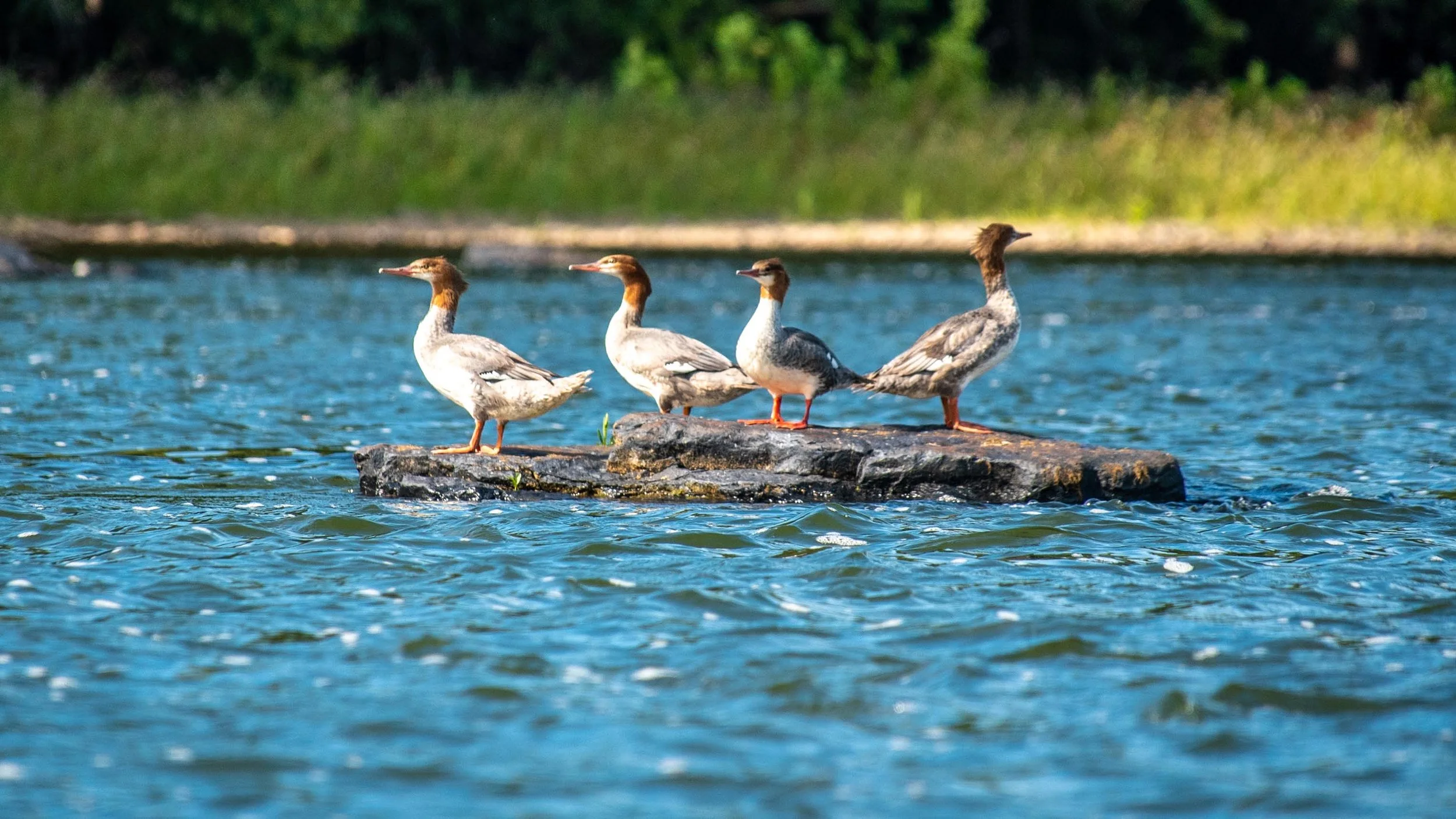
Mergansers
We spotted some mergansers before we reached what we thought was the island that we were supposed to camp on. No dice. The island was maybe 30 feet long and 10 feet wide and a hunting blind took up the majority of the space. Clearly not our island.
The Susquehanna used to run regular flat-bottomed barges up and down the river, but those days are long gone now. However, a paddle-wheel ferry service runs from Millersburg across to Mt. Patrick (http://www.millersburgferry.org/). To achieve water depths suitable for such boats, a large rock dam was constructed in the middle of the river, deepening the water there. Rather than head through the rapids at the far end of either side, we pulled up on the dam and scouted the islands ahead of us by binoculars. A few sites looked prospective. We now thought that we had passed Island 97 and were too tired to turn back. All we really needed for a site was a place large enough to put two boats and a few trees large enough to support us for a few hours while we slept.

After we hauled all of the gear up and over the dam and put back in on the other side, we realized that taking the rapids may have been a better choice after all. The water was faster and deeper on the sides. In the middle, we were back in ankle-deep water again. Ed walked perhaps a quarter-mile between some small islands lugging his boat train behind him in search of a suitable place to sleep. However, the prospective islands were not to be. Overgrown and under-treed. However, we finally spied it. Island 97 downriver, about another half a mile or so. But it was already occupied. We scouted ahead with the binocs for other opportunities and agreed that if none existed, we would ask to camp with the other folks on the island. There was no way we would make another 5 miles to Island 93.

We received another fresh dose of that Tester luck when we found that the island we scouted had been inhabited as a camp site. We hauled ashore and dumped a lot of water from Ed’s kayak, as we found that it had been slowly leaking about mid-day. A line was set up to dry wet gear and we sat down on our stools for a hot dinner of beef stew and beef stroganoff. One of the big mistakes we made was packing the sunscreen in a bag at the far back of Greg’s boat and refusing to take the time to unpack it when the sun came out midday. For that, we were terribly burned. Greg’s face was as red as a tomato and Ed’s legs were scorched.
Approximately 15 miles tomorrow to camp site. Unsure of ability to make that run. Physical exhaustion is deep. Considering bailing early.
We were truly run down. But, with hammocks up, the quiet rustle of leaves and spiders making webs on all of our gear, we disappeared into a deep restorative sleep.
Distance traveled: 18 miles.
Distance to go: 27 miles.