Down the Delaware!
“Without the soaring birds, without the great forests, the free-flowing streams, the sight of the clouds by day, and the stars by night, we become impoverished in all that makes us human.”

The Upper Delaware
Preparation
In the same way that we got hooked on African safaris, we’ve had a strong desire to get back a good overnight kayak trip. On our first run down the Susquehanna in 2022, we pushed through 40 miles of shallow, low-flow water from Hoover’s Island to Fort Hunter. In 2024, we finally bought our own boats and after last year’s plans fell apart, we were determined not to miss another chance.
Instead of continuing down the Susquehanna, we chose the Delaware River for this excursion. It’s deeper, faster, and far more popular. The Delaware is one of the last untamed rivers in the country and although there have been efforts to control it, it remains the longest free-flowing river in the Eastern US. From upstate New York, two branches merge near Hancock, New York and form the state line between northeastern Pennsylvania and the southwest corner of southern New York, before turning south at the junction of New York, New Jersey, and Pennsylvania at Port Jervis. Over the course of its 282-mile journey to the Delaware Bay, it drops a little over 2,500 feet. Our route would run from the end of the Upper Delaware at Sparrow Bush, NY through the heart of the Middle Delaware to Smithfield Beach, PA—a total of 42 miles. We planned to run about 20 miles the first day, then about 15 the next, and wrap up early on Labor Day.
Gear
We applied some lessons and cut down from the ridiculous amount we carried on our first trip. Ed even left his anchor at home. Here’s what we did bring.
Cameras
Nikon D7000 with Sigma 150–600mm lens. It’s an older setup, but if it goes into the drink, it’d be better than the heavy artillery.
Nikon D7200 with Sigma 18–300mm lens
Suction mount and clamp mount for phones or the 18-300 mm lens. No tripods this time.
Instead of printed maps, we went digital, using the Paddleways app for navigation and distance tracking.
Camping & Cooking
Hammocks, a tent just in case
Ground pads, sleeping bags, camp pillows
Lantern, tarps, rope
Two small camp stools, deck of cards
Jetboil stove, camp cutlery, cups
Matches, flint, small hatchet
Fishing rod, in the hopes of catching our dinner
Kayak Gear
Towels, large sponge, climbing rope for towing
Carabiners, tie-downs, duct tape (gotta have the duct tape)
Dry bags for critical gear
The first aid kits included small kayak parts, a screwdriver, and mini crescent wrench
Food
PB&Js, granola bars, fruit snacks, trail mix, Goldfish
Mountain House freeze-dried dinners (beef stroganoff is the best choice. Fight me.)
Taylor Ham & cheese bagels for breakfast
Homemade beef jerky and Amish smoked cheese
Water bottles and bladders, plus a water filter kit for refills
Clothing
Zip-off pants, t-shirt, lightweight long-sleeve
Thermal shirt, flannel
Greg brought a packable coat. Ed did not. Lows were expected in the upper 40s and highs in the low 70s.
All-in-all, we packed lighter than last time, though there’s still room to trim. Next time, we might ditch the stools and hatchet. Although the tent could be a significant gain for space and weight, it’s a great insurance policy for the unknown.
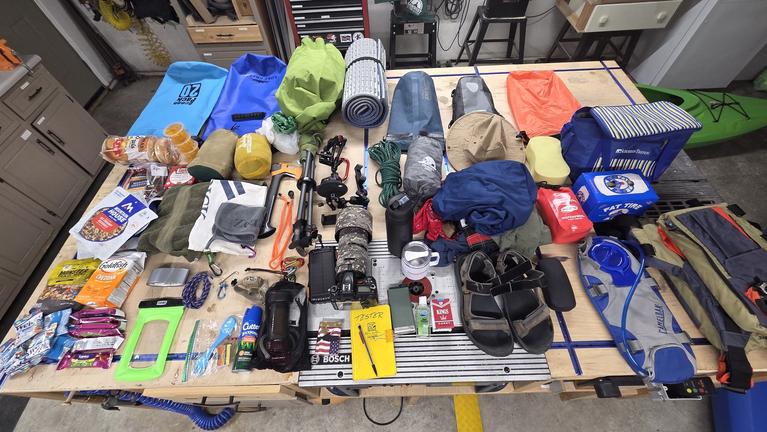
Somehow this all fits into the kayak.
Day 1: Launch
We met at Smithfield Beach to sort gear and shuttle boats with Greg’s Jeep. After pizza and beer in Port Jervis, we launched at 6:00 p.m.
The Delaware greeted us with sandstone cliffs and fishermen hauling in catches, including one gentleman who was night fishing for eels. The water was swift, drawing us in. We looked for a good place to camp but found none suitable in the first half mile. In a minute, we were faced with some roaring rapids and found ourselves bounding over the white-capped chop. Quiet water followed and we found a good place to land with a high ledge above the water and a rope swing tied from a mighty oak branch.
Greg’s boat had taken on some water in the rapids, presumably from water washing over the gunnels. Unfortunately, he had not properly sealed the dry bags and found some things waterlogged in the cargo hold. We dried out, set up camp, and talked deep into the night, watching stars and satellites peek out from behind clouds. At ten, we turned in, but the Christian camp across the river was just getting turned up and musical revelry floated to us until nearly 11.

Perched.
Day 2: Sparrow Bush to Milford
The rock ledge was not perfectly flat, so we spent the night constantly readjusting ourselves on the hard ground. By 05:00 we were breaking camp, repacking, and redistributing some weight in the boats. At 06:40 we were back on the water, mist rising in the sunrise. The current moved fast and silent as we sailed by the rocky outcrops before they faded away behind us. A small family of deer, including a piebald fawn, scampered from the shore as we passed. The river shallowed quickly as we got into Port Jervis and we were forced to get out and walk the boats back into the main channel. It was something we would be more vigilant of as we headed downstream. We had humped and walked our kayaks far more than we had cared to in the Susquehanna and we would not suffer the same fate here.
By 8:00 we reached the Tri-States Monument, where New York, New Jersey, and Pennsylvania meet in a singular point. A small granite block with the state initials and lines dividing them was the only marker. It was dirty, worn down, and sported a graffiti smiley face in black spray paint on one side. Greg inspected his boat to find that he had taken on even more water in this traverse. We had not gone through any significant rapids, so it was unlikely that the water was coming in over the gunnels. After draining half a gallon of water, we set about duct-taping the drain plug at the rear of the kayak. We lost nearly 45 minutes there for repairs, but better to find our issue there than somewhere downstream in less favorable circumstances.


Back on the river we were met with a flurry of wildlife: kingfishers, herons, egrets, mergansers, geese, ducks, and even a bald eagle. A herd of deer grazed in the tall grass on the shore. The water was crystal clear in the bright morning and flowing fast again. We stopped at a small island three miles on for food and additional duct tape while an eagle watched from a branch overhead. With repairs made, we pushed off again, pressing hard to Milford.
If you’re a good listener, the river will talk to you. Deep water is often slack, or dead, with little to no current. Some ripples in the distance or a little whitecap let you know a change is coming. The river will shallow, the current will quicken, and you will need to decide which part of the channel to get into before you get into the next set of rapids. The channel morphology itself was controlled by how the water was being moved in the channel. Straight section with sandy banks on both sides? Simple shallow channel on the edges, deeper in the middle. River making a turn? The inside turn hosts the shallows and the sandbar, so the outside of the channel will be deeper on the cut bank. Watching bubbles or foam on the river will guide you to the fastest channel and prevent you from getting stuck in the shallows. At Quick’s Island we chose the wrong channel and ended up in the shallows, our boats dragging to a halt. Ed had to walk his out to deeper water, but Greg managed to free himself. As we headed into the slack water above Milford a headwind came into our faces, slowing our pace and killing our morale.
We needed a lift. Two young men on the shore provided it for us. Greg paddled over.
“Excuse me, are you guys from Pennsylvania?”
The man, clearly misunderstanding Greg, “Yes, this is the Pennsylvania side.”
Greg, playing his hand beautifully “How far to Philadelphia???”
The man guffawed audibly, his friend snorting in disbelief. “Oh, geez, hundreds… hundreds of miles! Oh man, you’re really far from Philadephia.”
Greg and I began to argue, tossing insults and curses at one another. Out of earshot, we broke out laughing. It was enough to bring us to Milford. It was 11:45. We had paddled 11 miles in about 5 hours. We were making great time. Our shoulders and elbows were on fire from paddling, but we were excited to get back on the water.

Milford
At 12:30 we put back in. Some gentlemen who got on the river just before us were intrigued by our trip and offered intel on which channels to take around some of the bigger islands coming up. We heeded their advice and passed Minisink Island, where the Lenape tribe had lived for thousands of years before Dutch settlers built a nearby village in the 1600’s. By now there were lots of other people around and we passed through several groups before breaking off at the north end of Namanock Island as the man had suggested. The river was shallow, but deep enough for our boats that we didn’t have to drag or walk them and fast enough that we traversed the length of the island quite quickly. It was 13:45 when we stopped, having completed 5 miles in a little over an hour. It was our best time yet and that got us excited. We stopped for food, water, and a candy cigarette before we headed back out. Our excitement died away as we got into another long straight stretch of slack water. Dead water means harder paddling, more exertion, and more exhaustion. We arrived at Dingman’s Ferry Launch at 15:15, stretched, said farewell to the two gentlemen from Milford, and headed down again.
It was a leisurely four miles in the late afternoon to Shapanack Island to find a place to camp (don’t worry, the controversy about the spelling of the island name has been settled). Suitable places were scarce and we were forced to portage (carry) our kayaks about 200 feet inland and then our gear another 150 feet to a good site. We made dinner over the jet boil and determined that we would be able to finish out our journey the next day as we had only 17 miles left to go. With minimal stops and a constant speed of 3 miles per hour, we could be done by noon. Our bellies full of beef stroganoff and our bodies aching, we turned in for the night.

Camp 2
A Brief History: Dingman’s Ferry & Tocks Island
Dingman’s Ferry was once a small town situated on the west bank of the Delaware River. All that remains are a few scattered buildings and the last remaining privately-owned toll bridge in the country. Drivers can pay $2.00 to cross from Montague to Dingman’s Ferry.
During the height of the Great Depression in the 1930’s, FDR enacted an executive order to found the Civilian Conservation Corps. The CCC worked on infrastructure projects across the country to offset the high unemployment at the time. The Army Corps of Engineers was also busy scoping areas for potential projects and the construction of a dam along the Delaware was seen as a candidate to provide power and water to New York City and Philadelphia. However, it was scrapped until the 1950’s when hurricanes Connie and Dianne caused significant flooding on the river, killing over 100 people. A flood mitigation effort along the Delaware was revived, which included a proposal for a dam at Tocks Island just south of present-day Smithfield Beach. The plan was to construct a massive dam 3,200 feet wide across the Delaware Water Gap, impounding water 40 miles upstream and a mile wide. The reservoir would be a place for recreation, water, and power generation for an expanding urban population. Lyndon B. Johnson declared in 1965 at the signing of the bill:

The Delaware Water Gap National Recreation bill authorizes the creation of a 72,000-acre national park in the great State of Pennsylvania--halfway between New York and Philadelphia. A full 15 percent of this Nation’s entire population, almost 30 million people, will live within 100 miles of this reservation. Confined within the discomforts of noise and ugliness, surrounded by decaying buildings and despoiled landscapes, these people of ours yearn for beauty and hunger for the opportunity to find refreshment in nature. These yearnings have their roots deep in our American dream: an almost mystical dream of virgin forests and rich, deep soil, and a place where a man could try to discover the meaning of his life.The Delaware Water Gap National Recreational Area will be just such a place. Here will come as many as 150,000 visitors in 1 day. Here will come more than 10 million people in 1 year. Here they will come and they will swim and they will fish and they will camp out, and their lives will be infinitely richer because they came this way.
The government began to acquire property along the footprint of the reservoir through either purchases of land or through eminent domain. More than 6,000 properties were bought and 4,000 families were forcibly removed from towns along the river (including Dingman’s Ferry) before demolition of structures began to keep out squatters. These lands constituted the Delaware Water Gap National Recreation Area. National Recreation Areas are, by definition, a strip of land that surrounds a major reservoir. Lake Mead and Glen Canyon NRA’s out west are great examples. Although the land was acquired, several factors prevented the dam project from ever starting. The geology of the location would not support the massive earthen dam in that location, the financial cost of the dam could not be justified as the United States entered the Vietnam war, a growing environmental movement, anti-government sentiment in the valley area, and alternative methods of power generation and water supply scuttled the project by 1975.
A new movement has been taken up to reallocate the lands of the Delaware River National Recreation Area into the Delaware River National Park and Lenape Reserve. The logic is that the Recreation Area is only valid if the reservoir and dam had been built. Since it has not been constructed, the lands should be transferred into a National Park since they are already under the purview of the National Park System. The national park would require no additional lands and would return some of the land to the Lenape tribe, who have existed in this part of the world for millenia.
Day 2: Shapanack to Smithfield Beach

Great Blue Heron
Ed woke up at 3:00 again. In the dark, he heard something. Was it a deer? A raccoon? A bear? No, just a falling leaf as the temperature dropped into the 40’s. At 4:00, coyotes could be heard just north of our camp and at 4:30 Ed heard a low growl. Hanging in our hammocks, we were delicious little aerial burritos for any large predator that might be curious and hungry. Ed was on high alert. There is no place for other thoughts when survival is on the line. A scraping plastic sound forced him to pull out his bear mace, his knife, and headlamp as he searched for the source of the noise. Nothing. But that was it. He was up. On watch. Greg awoke at 4:45, chastising Ed for shining a light in his direction. Time to get up.
Breakfast consisted of Taylor ham and cheeses on a bagel again as we listened to Infected Mushroom and DMX to get us hyped up for the morning. The boats were loaded by 6:30 and we pushed off. The clear night had been overtaken by a dense fog, shrouding the banks. It was dead silent on the water. Two beavers paddled along with us. We had noticed several piles of branches on the way down the day before and assumed they were from flood debris. In fact, they were beaver dens. While beavers sometimes build dams across small waterways, on larger water sources, they will build a den into the bank of the river with underwater entrances. We saw several more throughout the day.


The fog was impenetrable, which was good for us. It kept our sense on point, listening for the river to tell us what it had planned for us. Were there rapids ahead? How deep was the water? Where is the current? At Eshback we passed some anglers in the river before a small rapids section after Buck Bar. Some families were out now at 7:30 on the banks at various campsites. By 8:30 we reached the Bushkill access and got out to stretch and eat some jerky and cheese. The stretch south of Bushkill was dead. Flat dead for a good mile. It was hard paddling but we inched closer to the Walpack Bend. The river generally flows southwest, but here the geology forced the river to turn around northeast before resuming its southwesterly course. The fog had burned off by now and the sun was shining bright in the cool morning. At Turtle Island (Sambo Island on some maps) there are a series of connected Class 1 rapids. These were by far the most fun and it’s a shame that it only took us 5 minutes to run the half a mile section. Water crashed and splashed over the bow and the gunnels but it was exhilarating to drop through and around the bend. Another set of smaller rapids just above Depew Island were the last ones we would encounter. From there the water was slack as we passed Poxono Island and rounded the bend into the straightaway that took us to Smithfield Beach. At 11:45 am we landed. 42 miles. 42 hours.

One of the many eagles we saw along the river.
Hindsight
Our Susquehanna trip had prepared us for misery—shallow water, endless dragging, exhaustion. The Delaware was a wonderful reprieve: deeper, faster, exciting. And no one got marooned on an island this time.
We were really struck by the immense biodiversity on land, air, and water. Eagles were once a rare sight in the east. We saw 19 on our trip. Our campsite at Shapanack Island was littered with the shells of thousands of freshwater mussels and clams. We could quite literally see the fish in the water at the bottom of the riverbed.
For next time:
Drop some small gear (hatchet, stools) to save space
Consider starting at Bushkill and camping along Walpack Bend before finishing at Smithfield or Worthington State Park
We hope you’ve enjoyed this adventure. Join us again to see where the next river takes us!
